Travel to Ireland
Day 6 Burren, Cliffs of Moher (319 Km.)
(in 120 Km.) Burren National Park: The Burren (Irish: Boireann, meaning "great rock") is a region of environmental interest primarily located in northwestern County Clare, dominated by glaciated karst. A part of the Burren forms the Burren National Park. The hills of the Burren are composed of limestone crossed by cracks known as "grikes", revealing isolated rocks known as "clints". Arctic, Mediterranean and alpine vegetables bloom simultaneously in this region, due to their unusual environment. There are several trails to tour the park. We made one of the shortest ones, the white one, which first passes between hazelnuts, calcareous rocks and returning through a meadow overlooking Mount Mullaghmore and Lough Gealáin.
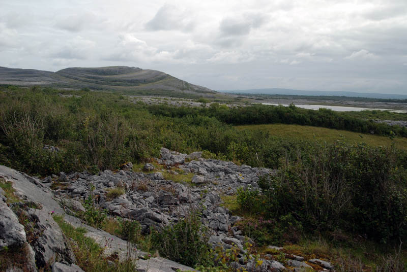
Burren
(in 16 Km.) Poulnabrone: The Burren region is rich in historical and archaeological remains. There are more than 90 megalithic tombs in the area, several dolmens and Celtic crosses in the town of Kilfenora, as well as a significant number of circular fortifications. The Poulnabrone dolmen (in Irish Poll na mBrón, "hole of sorrows") is an ancient burial that is in the Burren, of the Neolithic period, probably between 4200 a. C. and 2900 a. C. It consists of a smooth stone three meters long that rests on two other arranged as a door, and these in turn on a burial mound, which offers stability to the monument, and which in its origin must be taller than that is today.
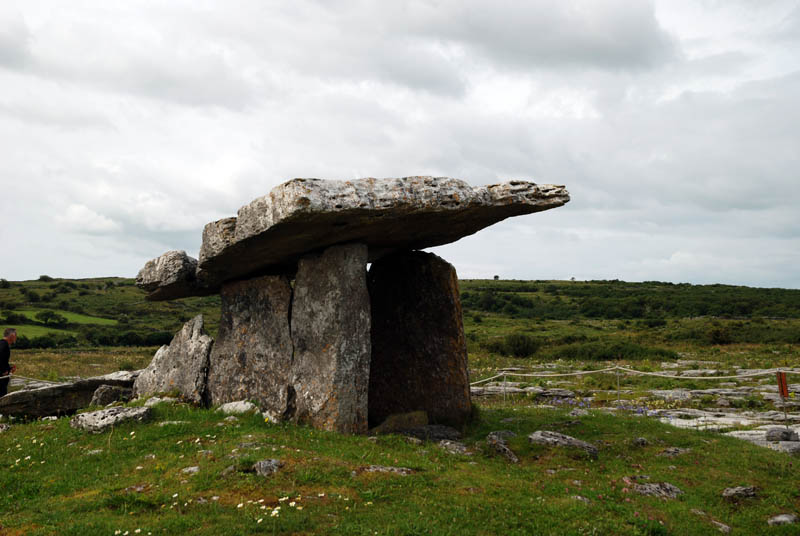
Poulnabrone dolmen
(in 7 Km.) Leamanegh Castle: Leamaneh Castle is a ruined castle located in the townland of Leamaneh North, parish of Kilnaboy, between the villages of Corofin and Kilfenora. It consists of a 15th-century tower house and a 17th-century mansion. The house fell into ruin at the end of the 18th century. Today, the ruins include both the tower house with its arrow slits (or "loops") and the four walls of the adjoining manor house with their mullioned and transomed windows. Unlike many of the castles in Ireland, Leamaneh is unmaintained and due to its poor state of repair not accessible.
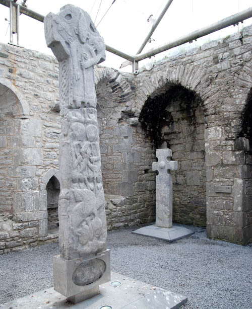
Kilfenora - St. Fachanan (Doorty´s Cross)
(in 6 Km.) Kilfenora: We stop in this village known as the "City of the Crosses" for its seven (now five) high crosses, to visit the Kilfenora Cathedral, dedicated to St. Fachtna (St. Fachanan). The present structure dates to between 1189 and 1200. It was built in the so-called transitional style with a nave and a chancel. In 2003, three high crosses from the site were removed for conservation by the Office of Public Works and from 2005 have been on display in the transept of the cathedral; amongst them the "Doorty Cross". We continue west of the graveyard and roughly halfway between the cathedral and the modern Catholic church to see another high cross (the "High Cross"), standing in a field.

Cliffs of Moher
(in 18 Km.) Cliffs of Moher: The most interesting visit of the day is the Cliffs of Moher (in Irish, Aillte an Mhothair), which are located on the southwestern border of the Burren region. The cliffs of Moher take their name from the ruins of the fort "Mothar", which was demolished during the Napoleonic wars to give rise to a signal tower. The O’Brien Toweris a circular stone tower located approximately in the middle of the cliffs. It was built by Sir Cornellius O´Brien in 1835 as a viewpoint for the hundreds of tourists who came to the place even at that time. The cliffs rise 120 m above the Atlantic Ocean at the point called Hag´s Head and extend along 8 kilometers to a height of 214 m.
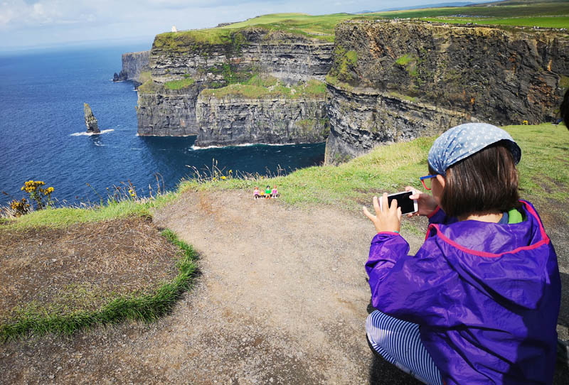
Cliffs of Moher
There is a path that runs along the cliffs along its entire length. The worst part of the visit is that the cliffs are very popular and in summer it becomes difficult to move along the path due to the multitude of people that circulate along it. They are the oldest natural rock structures in Ireland, geologists place the period of their formation 300 million years ago. These majestic rock formations open towards the Atlantic Ocean offering an observer the feeling of being on the edge of an abrupt wall. Another way to visit the cliffs is from the sea. Boats leave from the port of Doolin to the Aran Islands or until the base of the cliffs.
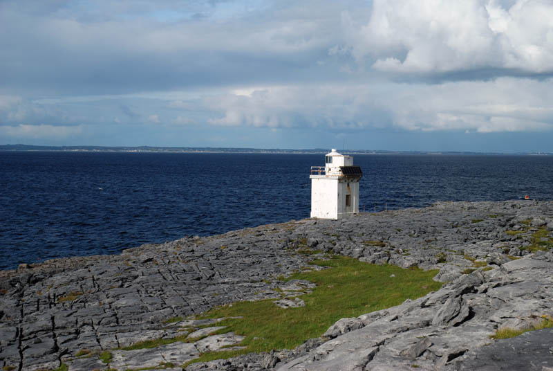
Black Head
(in 29 Km.) Black Head: We start the way back from Doolin, this time following the R477 road that advances along the coast, until we reach the lighthouse called Black Head Lighthouse. The most interesting part of this section is to see how the Burren limestone reaches the sea. In Black Head we find a small white lighthouse dating from 1936. From this point, excursions start up a hill from which we can enjoy the views over Galway Bay and the Aran Islands. The main problem of this place is that there is no parking to park the car.
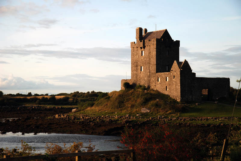
Dunguaire castle
(in 28 Km.) Dunguaire castle: Dunguaire Castle is a 16th-century tower-residence located near Kinvara. The castle has a tower 75 feet high and a wall of protection. Both have been restored and the inner courtyard is open to tourists during the summer. A medieval banquet is held every night with disguised artists reciting Irish literature and performing Irish music. It is said to be the most photographed castle in Ireland. We planned to visit it another day, but as the sun was just setting when we passed in front of it we stopped to photograph it.
(in 95 Km.) Ballintober: After dinner at Galway, we arrived again at our accommodation at the Tranquil Escapes B&B located next to the Ballintober Abbey, founded in 1216.