Travel to Switzerland, Liechtenstein, Innsbruck and Bavaria
Day 7 Erpfendorf - Zauberwald - Hintersee - Wimbachklamm - Erpfendorf (119 Km.)
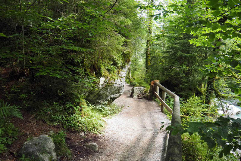
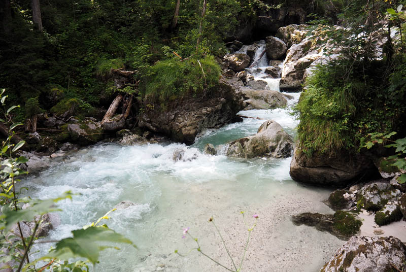
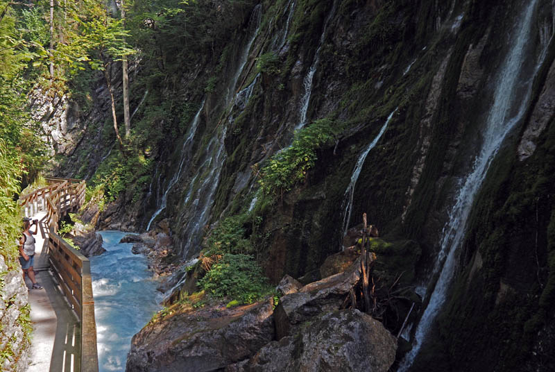
(in 48 Km.) Zauberwald: We began the second day of our visit to Berchtesgaden National Park with an early morning departure from our accommodation in Erpfendorf, heading back toward the park area. Our first stop was the Zauberwald, also known as the “Magic Forest,” a protected nature reserve located near Ramsau bei Berchtesgaden. This area is notable for its geological history, which dates back thousands of years. It was created by a massive rockslide from the surrounding mountains, which left behind an irregular terrain filled with enormous boulders, some of them towering several meters high. Over time, the area was reclaimed by vegetation, and today, thick moss and ferns cover many of the rocks, while tall coniferous trees provide shade throughout the forest. The Ramsauer Ache River runs directly through the reserve, shaping the landscape further with its fast-flowing waters. The river has carved out small rapids and pools, and several wooden bridges allow visitors to cross safely while observing these natural features. The Zauberwald is protected as part of the national park system and has a series of well-maintained trails, each clearly marked with directional signs and interpretive panels that explain the formation of the area and its ecological significance.
Zauberwald
We followed one of the main loop trails, which begins at a small parking area near the entrance and winds through the forest alongside the river. The path included several constructed viewpoints, strategically placed at locations where the river narrows or drops over small ledges, creating miniature waterfalls. These observation points are equipped with wooden railings for safety and benches for those who wish to stop and rest. Along the route, we encountered a number of informational panels describing the flora and fauna typical of this part of the Alps. The signage provided explanations in both German and English, making it accessible to a wide range of visitors. As we continued, we noticed the variety of plant life, from alpine wildflowers growing close to the forest floor to the dense canopy of spruce and fir trees above. The trail was generally flat with occasional gentle inclines, making it suitable for walkers of all ages. Several side paths branched off the main route, leading to alternative viewpoints, though we stayed on the marked trail to ensure we completed the circuit efficiently.
Zauberwald - Ramsauer Ache River
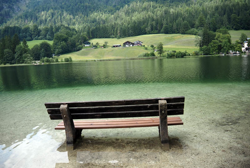
(in 1 Km.) Hintersee: After completing our walk through the Zauberwald, we continued directly toward the Hintersee, which is located a short distance from the forest and connected by a path that follows the Ramsauer Ache. The trail between the two sites is well-traveled and easy to follow, with clear signposts indicating distances and walking times. Upon reaching the lake, we explored the northern shoreline, where there is a small visitor area with facilities such as restrooms, parking, and picnic tables. The Hintersee itself is a small alpine lake surrounded by steep forested slopes, with crystal-clear water that reflects the surrounding landscape. There are trails encircling the entire lake, allowing visitors to walk completely around it if they choose. Along the route, there are wooden benches positioned at intervals, as well as informational boards describing the history of the area, including the role of the lake and forest in inspiring 19th-century painters who came to this region. Boat rentals are also available for those wishing to explore the water directly, though we focused on walking along the shore and observing the scenery from land. After completing a partial circuit of the lake, we returned to the main access point near the parking area to continue with our day’s plan.
Hintersee
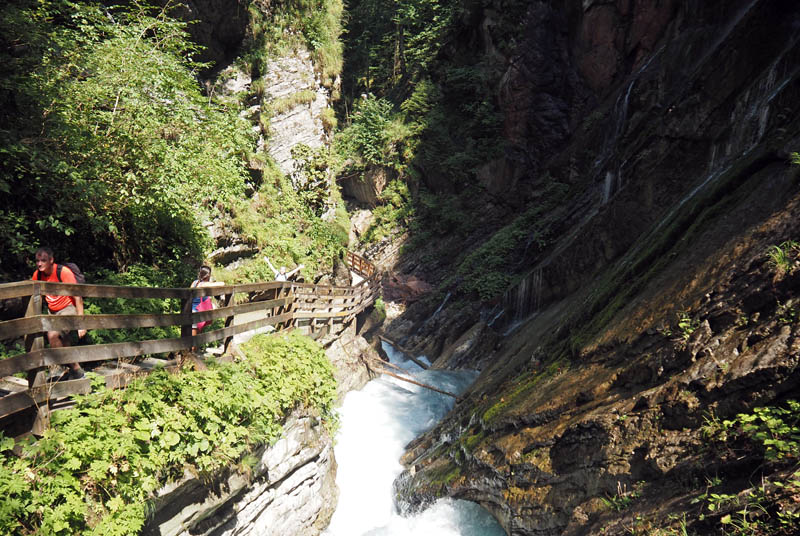
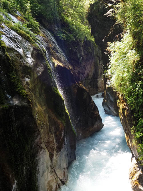
(in 6 Km.) Wimbachklamm: By midday, we returned to our vehicle and drove back toward Ramsau and the central area of the park to visit Wimbachklamm Gorge, which we had scheduled for the afternoon. Upon arrival, we purchased tickets at the entrance booth located near the Wimbach River and followed the designated trail leading into the gorge. The Wimbachklamm is a narrow canyon formed by centuries of erosion as the river carved its way through the rock. A wooden walkway has been built along the length of the gorge, attached to the rock walls in several sections, allowing visitors to safely traverse areas that would otherwise be inaccessible. As we progressed along the path, we encountered several small waterfalls cascading from the cliffs above, as well as pools of clear, cold water collecting in natural basins. The sound of the rushing river was constant, and in some areas, mist from the waterfalls reached the walkway. Several viewing points were integrated into the structure, providing space for stopping to observe the formations and take photographs. Informational signs along the route explained the geological processes that shaped the gorge, including glacial activity during the last Ice Age and ongoing erosion caused by the flowing water.
Wimbachklamm Gorge
The walkway through Wimbachklamm is relatively short, typically taking twenty to thirty minutes to complete. After passing through to the exit, visitors can either return directly or continue exploring the Wimbach Valley, which stretches further into the mountains. We spent some additional time at the valley’s lower section, where the landscape widens, and the river flows more gently across a gravel bed. Small wooden bridges cross the water in several places, and there are designated picnic areas with tables and benches for resting. This section of the park provides access to several long-distance hiking trails that lead to alpine pastures and mountain huts, though we limited our visit to the immediate area near the gorge entrance. Once we were ready to leave, we returned to our vehicle and began the drive back toward Erpfendorf, retracing our route through the park and the surrounding alpine villages.
Wimbachklamm Gorge
(in 57 Km.) St. Johann in Tirol: The return journey took us along scenic mountain roads, passing through rural areas with traditional farmhouses and small towns. Upon reaching the neighboring town of St. Johann in Tirol, we made a brief stop to take care of some practical needs before heading to our accommodation. One of our priorities was to visit a self-service laundromat, where we were able to wash and dry our clothes after several days of travel. While waiting for the laundry cycles to finish, we walked through the nearby streets to get a general sense of the town. St. Johann features a mix of residential neighborhoods and a compact town center with pedestrian streets and small squares. The central area includes local shops, bakeries, restaurants, and services catering both to residents and to visitors staying in the region.
Wimbachklamm Gorge
(in 7 Km.) Erpfendorf: After completing our laundry and collecting our belongings, we returned to our vehicle and drove the short distance back to Erpfendorf, where we concluded the day’s activities having dinner at Cafe Hirzinger Pizzeria.